By William Strasmore, Lake Erie Times Investigative Reporter
While Western New York residents are more accustomed to tracking lake-effect snow than tropical depressions, the upcoming 2026 Atlantic hurricane season carries implications that stretch far beyond the coastline. Forecasters are currently monitoring a complex atmospheric “tug-of-war” between a developing El Niño and record-warm ocean temperatures, a dynamic that could dictate weather patterns across the eastern United States for the remainder of the year.
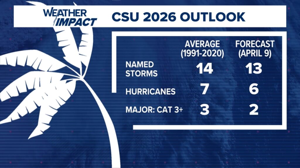
Early outlooks from the experts at Colorado State University (CSU) suggest a “quieter” year on the horizon. However, as history has shown, a below-average forecast is no guarantee of safety. For communities in the path of these systems—and those inland like Buffalo that often deal with the remnants of tropical moisture—preparedness remains the priority.
“A below-average forecast doesn’t mean you won’t get an impactful storm,” explained Levi Silvers, a research scientist at CSU. “Even some of the most impactful storms we’ve had have been during quiet seasons.”
The 2026 Atlantic Forecast at a Glance
The initial predictions for the 2026 season indicate a decrease in overall activity compared to recent record-breaking years. Here is the breakdown of the anticipated tropical activity:
| Storm Category | CSU 2026 Prediction |
|---|---|
| Named Storms | 13 |
| Hurricanes | 6 |
| Major Hurricanes (Category 3+) | 2 |
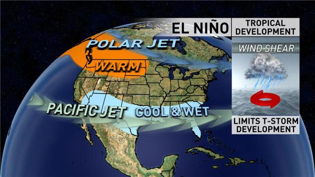
El Niño: The Atmospheric Suppressor
The primary driver behind this tempered forecast is an emerging El Niño. This climate pattern, defined by warmer-than-average waters in the central and eastern Pacific, has a ripple effect on global weather. In the Atlantic, El Niño typically creates hostile upper-level winds, known as wind shear, which can effectively “shred” developing tropical systems before they can organize into powerful hurricanes.
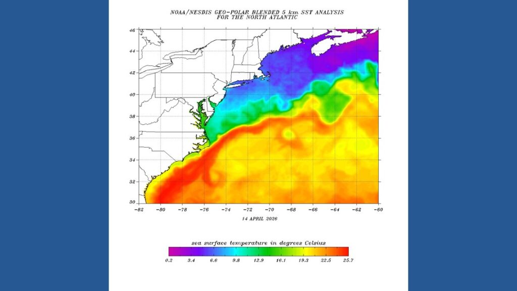
Ocean Temperatures Provide the Fuel
While El Niño acts as a deterrent, record-warm sea surface temperatures act as high-octane fuel. Silvers describes the situation as a seasonal battle: “You can think of El Niño as being a negative influence and the warm sea surface temperatures being a positive influence on Atlantic hurricanes.”
Off the U.S. East Coast, temperatures fluctuate significantly, but climate data confirms a steady upward trend over the last half-century. These warmer pockets can provide enough energy for a storm to overcome wind shear, especially as they move north toward the Mid-Atlantic and Northeast.
Historical Lessons: Andrew and Melissa
History serves as a stark reminder that “quiet” years can be catastrophic. Hurricane Andrew, one of the most destructive storms in American history, struck during the El Niño year of 1992. Similarly, the more recent Hurricane Melissa proved that timing is everything.
“For a lot of the time when Melissa was just a tiny tropical storm, there were high winds pulling it apart,” Silvers noted. “But then eventually, when the wind shear calmed down for a couple of days, it just took off. It was able to take all of that energy and build quickly.”
Why This Matters for Western New York
At the Lake Erie Times, we understand that “hurricane season” might feel like a distant concern. However, local weather patterns in Buffalo and the broader WNY region are frequently influenced by these Atlantic giants. Remnants of hurricanes often track inland, bringing torrential rain and localized flooding to the Great Lakes basin.
The official season runs from June 1 to November 30. NOAA is expected to release its first comprehensive outlook in late May, with CSU providing critical updates in June, July, and August. Regardless of the number of predicted storms, the message remains the same: it only takes one. Residents are encouraged to stay prepared and informed throughout the season.
For more in-depth reporting on regional climate impacts and community news, visit our Community Section.